January 27, 2013
Volume 11 | Issue 3 | Number 0
Preliminary Remarks
Does it make sense to refer to a Chinese “tributary system?” A number of influential Western scholars, including John Wills Jr., James Hevia and Laura Hostetler, have argued that it does not—largely on the grounds that previous China scholars, John K. Fairbank “and his followers” in particular, have over-generalized its historical significance. The result, however, has been that much of Fairbank’s painstaking and valuable research on the structure and functions of the tributary system has been ignored. Although Fairbank may well have overestimated the degree to which Chinese assumptions about tribute shaped Qing policy toward foreigners, it seems unhelpful and misleading to suggest that they were of no consequence whatsoever.
Also, as Gene Cooper has reminded me in a recent email, it is important to view the tributary system as part of a much larger framework of Ming-Qing tributary relations. This is a point that Mark Mancall made long ago in his essay for Fairbank’s edited volume, The Chinese World Order (1968). As Cooper puts the matter, “the very structure of the Chinese state was ‘tributary’,” in the sense that Eric Wolf uses the term in Europe and the People without History (second edition, 2010). Using Wolf’s conception, and following Karl Polanyi’s idea of “redistributive” transactions, Cooper argues persuasively that “European feudal systems and China’s bureaucratic redistributive system were both tributary structures (insofar as they involved the citizenry passing tribute (taxes) up the pipe either to the local lord or to the central government).” Viewed in this way, “European feudalism and the Chinese bureaucratic redistributive system represented differing outcomes in the struggle between centripetal and centrifugal forces.” Once one accepts this characterization of the Ming-Qing state, it is easier to recognize that the Chinese government’s treatment of foreigners was fundamentally no different than its treatment of its own subjects (who were expected to yield “domestic” tribute on many occasions—for instance in the “tribute grain” [caoyun or caogong] system). Figure 1, from a widely distributed Ming dynasty encyclopedia, provides an excellent visual illustration of the way that Ming-Qing tributary rituals mirrored “domestic” rituals.
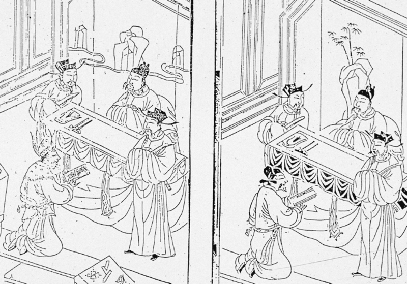
Figure 1. Images from a Ming dynasty work titled Wanyong zhengzong buqiuren quanbian (The complete orthodox ask-no-questions [handbook] for general use; 1609). See also R.J. Smith, Chinese Maps: Images of ‘All under Heaven’ (1996), p. 14
For his part, Takeshi Hamashita provides a valuable perspective on “external” tribute relations that avoids the extremes of both Fairbank and his critics. His China, East Asia and the Global Economy: Regional and Historical Perspectives (2008), makes a powerful case for the existence of a long-standing, vibrant, multifaceted and organically evolved “network of [tributary] relations linking the center and its peripheries, including the provinces and dependencies of the [Chinese] Empire, rulers of native tribes and districts, tributary states and even trading partners.” In other words, the tributary system provided a framework—both land-based and maritime—for economic and other interactions in which multiple actors played multiple roles. It may have been a “Sinocentric” system, as Hamashita avers, but it was certainly not a static or a monolithic one. As Song Nianshen emphasizes in a recent online article (see “Bibliographical Note” below), the tributary system “was an institutional mechanism mutually constructed by both the central and peripheral [East Asian] regimes.”
A balanced analysis of the so-called tributary system requires, then, a historically sensitive appreciation of its assumptions and its institutions, its theories and its practices, its goals and its actual outcomes. This kind of understanding compels us to consider, among other things, exactly how the offering and acceptance of “tribute” were conceived (by all parties; not simply the Chinese), and how much flexibility the system allowed. Clearly any conception of the tributary system that suggests a stagnant, “unchanging China” is hopelessly wrong-headed. Yet to ignore or downplay the tributary system as an important historical and cultural frame of reference for Chinese emperors and officials would be equally misguided.
The Tributary System and Qing Cartography
From the Song dynasty onward, most large-scale Chinese maps that deal explicitly with foreigners refer to a set of institutionalized practices involving, among other things, the formalized “presentation of tribute” (jingong, zhigong, chaogong, etc.) to China by “representatives” of foreign countries. A few prominent examples of such maps include the anonymous Huayi tu (Map of China and the barbarians; 1136); Yu Shi’s Gujin xingsheng zhi tu (Map of Advantageous Terrain, Past and Present; 1555); Luo Hongxian’s Guang Yutu (Enlargement of [Zhu Siben’s fourteenth century] Terrestrial map; 1579; Cao Junyi’s Tianxia jiubian fenye renji lucheng quantu (A complete map of allotted fields, human events and travel routes [within and without] the nine borders under Heaven; 1644); and any number of the popular cartographic works known generically as “complete maps of all under Heaven” (Tianxia quantu)—works that seem to have dominated Chinese visual representations of “the world” from around 1700 until the latter part of the nineteenth century. Even the maps of the world produced by the Jesuits in the seventeenth and eighteenth century (see below) often refer to a Chinese tributary system.
Let us look more closely for a moment at the popular Tianxia quantu genre. [Figures 2-4] Invariably, at least in my experience, these maps include textual information on important Sino-foreign tributary relationships, including their historical background and their contemporary status (frequency of missions, indications of major tributary routes, etc.) In so doing they reveal a rich lexicon of tributary terminology. The preface to each map of this variety refers explicitly to the process by which barbarian envoys come to China and offer themselves as vassals of the Qing dynasty. This process of symbolic submission is often described as an arduous one, involving “the scaling [of mountains], the sailing [of seas], and several stages of translation [ti hang chong yi].”
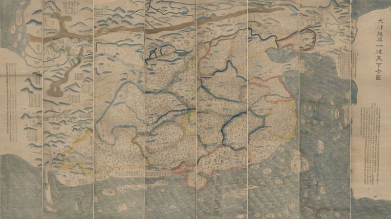 Figure 2: Da Qing wannian yitong tianxia quantu (Complete map of all under Heaven, eternally unified by the great Qing; 1811) Source: The Library of Congress Map Room (online collection)
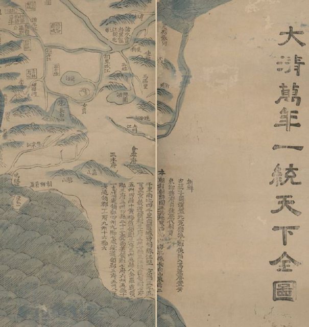 Figure 3: Detail from the 1811 Da Qing wannian yitong tianxia quantu, including a long description of Korea’s historical relationship with China. Source: The Library of Congress Map Room (online collection)
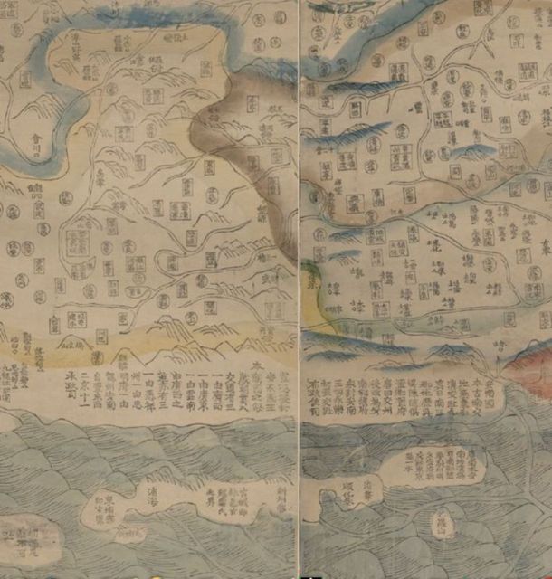 Figure 4: Detail from the 1811 Da Qing wannian yitong tianxia quantu, including a long description of Vietnam’s historical relationship with China. Source: The Library of Congress Map Room (online collection)
Such cartographic clichés reflect deep-seated attitudes toward foreigners expressed in a number of official documents, including the Huang Qing zhigong tu (Illustrations of the tribute-bearing people of the imperial Qing [dynasty]; 1761), the Huang Qing fanbu yaolüe (Essentials of the vassal [tribes] of the imperial Qing [dynasty]; 1845), and the Chouban yiwu shimo (Management of barbarian affairs from beginning to end; 1880). The prefaces to each of these compilations display the same condescending tone. The first emphasizes how “within and without the empire united under our dynasty, the barbarian tribes have submitted their allegiance and turned toward [Chinese] civilization [xianghua].” The second, by the great Qing geographer, Li Zhaoluo, refers to the way the emperor “nourishes [his dependencies] like their father and their mother,” and “illuminates them like the sun and the moon.” And the third, using much the same language as the first, describes the historic process by which foreigners gravitate to China, become “cultivated” and learn “elegance and etiquette.”
The ten volumes of the Huang Qing zhigong tu provide a detailed picture of the Qing tributary system in its theoretical heyday. Most of these volumes deal with the peoples of Inner Asia and the ethnic minorities of Southwest China. The first, however, focuses on China’s overseas tributaries, listed in the standard order: Korea, the Liuqiu Islands, Annam (Vietnam), Siam, Sulu, Laos, Burma, and the Great Western Sea (Da Xiyang). [Figures 5-7] These discussions are followed by sections on the Small Western Sea (Xiao Xiyang), England, France, Sweden, Holland, and Russia. There are also sections on Asian kingdoms such as Japan, the Philippines, Java, Malacca and the Soloman Islands. This work is in several respects comparable to Jacques Grasset de Saint-Sauveur’s (1757-1810) Tableaux des principaux peuples de l’Europe, de l’Asie, de l’Afrique, de l’Amérique, et les découvertes des Capitanes Cook, La Pérouse, etc. etc. (1798).
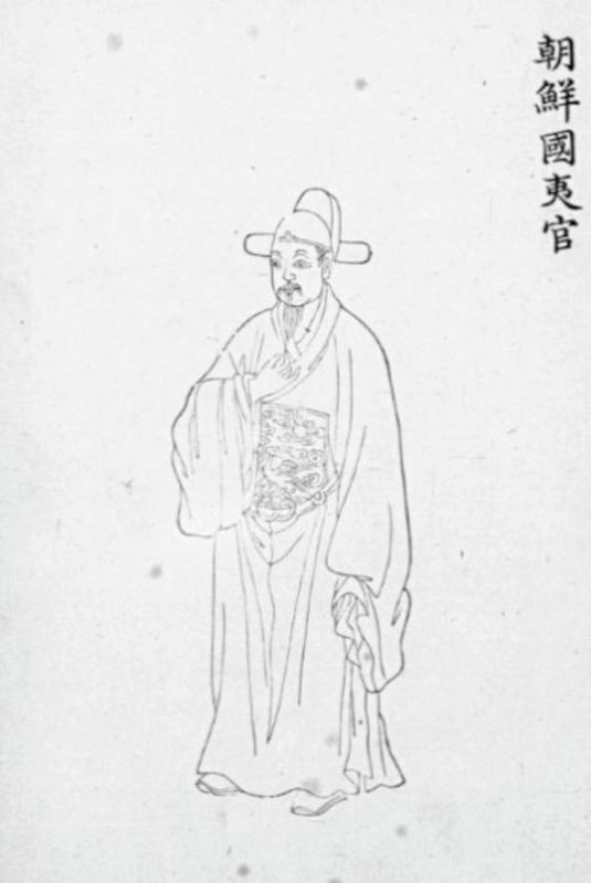
Figure 5: Depiction of a Korean official. Source: Huang Qing zhigong tu (Illustrations of the tribute-bearing people of the imperial Qing; 1761)
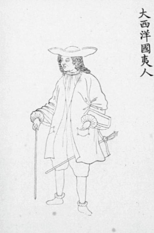
Figure 6: Depiction of a person from the Land of the Great Western Sea. Source: Huang Qing zhigong tu
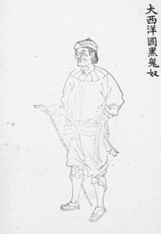
Figure 7: Depiction of a “black ghost’ [i.e. African] slave in the Land of the Great Western Sea. Source: Huang Qing zhigong tu
Both of these ethnographically oriented productions contain texts and illustrations that project worldviews reflecting the assumed cultural superiority of their respective “centers”—China and Europe respectively. And in both cases, misconceptions abound. In the case of the Huang Qing zhigong tu, which lacks any sort of cartographic representations, the so-called Land of the Great Western Sea (Da Xiyang guo) is located vaguely in the Atlantic region and identified both with Italy and Portugal. Other Western nations, including England, France, Sweden, Holland, and Russia are lumped together indiscriminately with Asian countries such as Japan, Borneo, Cambodia, Java, and Sumatra. Modern France is confused with Ming dynasty Portugal, and Portugal is naturally confused with Spain (since Spain ruled Portugal from 1580-1640); and England and Sweden are recorded as countries dependent on Holland. According to the Huang Qing zhigong tu, Italy presented tribute in 1667 (it was actually Holland that did so), and the Pope himself is reported to have once brought tribute to China. In religious matters the Huang Qing zhigong tu informs us that the Portuguese/French/Spanish were Buddhist countries before they accepted Catholicism.
The same kind of misinformation can be found in the section on “tributary states” in various editions of the Da Qing huidian (Collected statutes of the great Qing [dynasty]). Thus we read in the Collected Statutes of the Jiaqing reign (1796-1820), that “Portugal/Spain [Gansila] is in the northwestern sea near England,” and that “France [Falanxi], also called Fulangxi, is the same as Portugal [here, Folangji].” After absorbing the Philippines (Lüsong), this account goes on to say, “they [the French/Portuguese/Spanish] divided their people and lived there, still governing it at a distance.” Other nineteenth century Chinese sources identify Portugal not only with the Land of the Great Western Sea but also with Italy (Yidaliya)—apparently because in the late seventeenth and early eighteenth century a number of Italian missionaries had entered China through the Portuguese settlement at Macao. Small wonder, then, that Qing mapmakers found it difficult to acquire accurate data on foreigners and foreign places.
More reliable information was, however, available, as we can see from a large (147 x 105 cm), hand-colored cartographic scroll produced by a scholar named Zhuang Tingfu (1728-1800) in 1794 (unfortunately, this document, which is available online at the Library of Congress Map Room website, could not be reproduced clearly here). The title of Zhuang’s production is: Da Qing tongshu zhigong wanguo jingwei diqiu shi (Model of the myriad tributary states of the great Qing dynasty from around the globe). This work includes four maps. Two of them are relatively unsophisticated renderings that are often included in tianxia quantu productions—notably, the various editions of Ma Junliang’s (fl. 1761-1790) Jingban tianwen quantu (Capital edition of a complete map [based on] astronomy; c. 1790). One of these maps is based on a very loose rendering of Matteo Ricci’s mappamundi that appears in the Ming encyclopedia Sancai tuhui (Illustrated compilation of the Three Powers; 1607) [Figure 8]; the other is borrowed from a similarly structured Chinese map of the eastern hemisphere, first published by Chen Lunjiong (fl. 1703-1730) in his Haiguo wenjian lu (Record of things heard and seen in the maritime countries; 1730) [Figure 9]. But the other two maps are more “modern” looking renderings of the Eastern and Western hemispheres, both produced by Zhuang himself. These latter two spherical maps were reprinted by Western-oriented Korean exponents of “practical learning” during the 1830s.
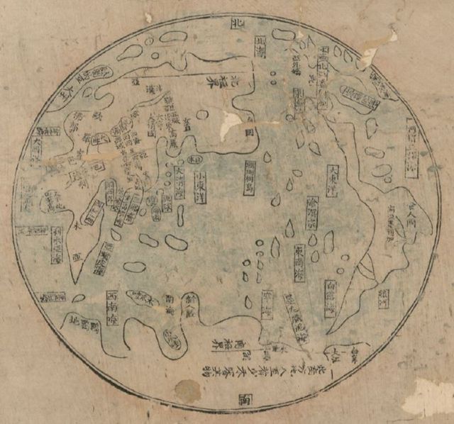
Figure 8: Detail from the Jingban tianwen quantu, showing a world map derived from the Sancai tuhui (Illustrated compilation of the Three Powers; 1607). Source: The Library of Congress Map Room (online collection)
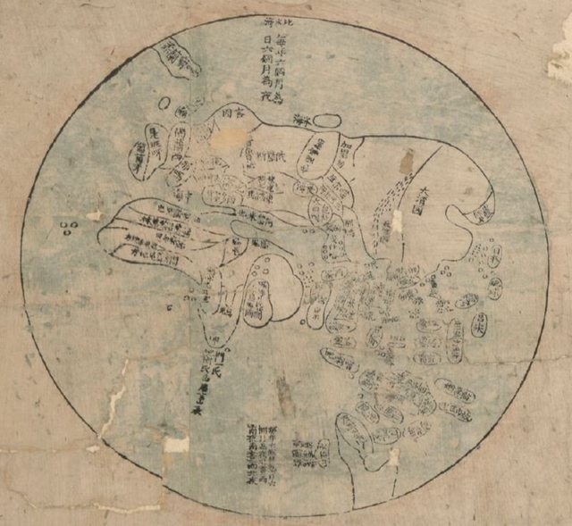
Figure 9: Detail from the Jingban tianwen quantu, showing a map of the Eastern Hemisphere, first published by Chen Lunjiong in his Haiguo wenjian lu (Record of things heard and seen in the maritime countries; 1730). Source: The Library of Congress Map Room (online collection)
A pair of long, written inscriptions, totaling about five thousand characters illustrate Zhuang’s two major themes: one, the transmission to China of new Western scientific knowledge by Jesuit and other missionaries in the eighteenth century; the other, the historic process by which foreigners came to be ruled (laiwang) as vassals; that is, they “knocked on [China’s] gates,” “sincerely offered tribute,” and asked to become “attached” (shu) to the Central Kingdom. The interesting feature of Zhuang’s document is the way it accommodates simultaneously the idea of embracing new knowledge from the West and the notion of enrolling Westerners as traditional-style tributaries.
From a scientific standpoint, Zhuang seeks to show that he has learned a great deal from the Jesuits about geography, cartography and astronomy, which, indeed, he did. He waxes at length about latitude and longitude, time and seasonal change, the circumference of the earth (90,000 li), the north and south poles, and so forth. He also writes knowledgeably about how different cartographic projections yield different pictures of the world.
Figure 10: The Eastern Hemisphere of Matteo Ricci’s Kunyu wanguo quantu (Map of the myriad countries of the earth; 1602). Source: The Library of Congress Map Room (online collection)
According to Zhuang, previous maps, including those offered by the Jesuit fathers, Matteo Ricci (1552-1610) and Ferdinand Verbiest (1623-1688), distorted China’s size by placing it too far north, thus compressing it (making China appear too small and the foreign countries, too big). [Figure 10] His own map, drawing upon the work of the famous Qing scientist Mei Wending (1633-1721), provides, he says, a more accurate picture. Significantly, Zhuang cannot resist remarking on how, cosmologically speaking, the Chinese are fortunate to have been born in the Central Land (Zhongtu), where the radiance of the sun nourishes them like a sovereign or a father—unlike those people whose misfortune it is to be in far northern or southern regions, where beneficial qi is less direct and therefore not very helpful.
Although Zhuang devotes a great deal of attention to science, his primary concern is a cultural one: the Chinese tributary system. In particular, the Da Qing tongshu zhigong wanguo jingwei diqiu shi commemorates the well-known Macartney embassy of 1793, which, in turn, marked what Zhuang considers to be the high water mark in the development of China’s age-old system of hierarchical foreign relations. This system, he notes, expanded significantly during the Kangxi and Qianlong reigns to include many new parts of the “Western Regions.” The peoples of these areas, Zhuang goes on to say, have been registered as part of the Chinese empire [ru banji], and having offered tribute to the Qing dynasty, along with the British, had engaged in no official communication with China prior to 1793.
Earlier maps, Zhuang tells us, did not include all of China’s tributaries; but the Macartney mission, together with the “coming to court” of other tributaries, and the “return” (laigui) of various tributary peoples from the “Western regions” during the eighteenth century, offers a fitting moment to celebrate the transformative effect of the throne’s glory (shenghua) with a set of maps. His renderings, then, are respectfully offered on this magnificent occasion. Significantly, but not at all surprisingly, Zhuang’s remarks about the civilizing role of the Chinese emperor (shengjiao) correspond closely to those provided in the major cartouche of Ma Junliang’s Jingban tianwen quantu and other such maps.
It is worth mentioning that decades before the Macartney embassy of 1793 the Qianlong emperor had already commissioned a set of paintings that conveyed the same sense of collective “barbarian submission” that came to be celebrated in the Da Qing tongshu zhigong wanguo jingwei diqiu shi. Indeed, at almost exactly the same time that the Huang Qing zhigong tu appeared in print (1761), two of the emperor’s court painters—Yao Wenhan (dates unknown) and Zhang Tingyan (1735-1794)—produced a beautifully executed work titled “The Myriad [Tributary States] Coming to Court” (Wanguo laichao), which depicted representatives from dozens of countries in East Asia and the West, all gathered together with their “local products” in the Forbidden City under the watchful eye of Qing officials. [Figures 11-13]
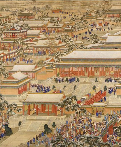
Figure 11: The Wanguo laichao tu (c. 1760). Source: The Palace Museum, Beijing.
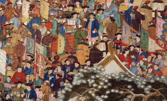
Figure 12: Details from the Wanguo laichao tu, showing tributary representatives from predominantly European states such as England, France, Holland and the Great Western Ocean (above), and Asian states such as Vietnam, Japan, the Liuqiu Islands and the Philippines. Source: The Palace Museum, Beijing.
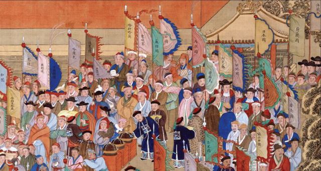
Figure 13: Details from the Wanguo laichao tu, showing tributary representatives from predominantly Asian states such as Vietnam, Japan, the Liuqiu Islands and the Philippines. Source: The Palace Museum, Beijing.
Illustrations such as these, along with the eighteenth century maps by Ma, Zhuang, and others, bring into sharp focus the issue of how best to characterize the Qing tributary system. Was it, in fact, a “system” and, if so, what role did it play in China’s foreign relations? James Hevia’s book, Cherishing Men from Afar: Qing Guest Ritual and the Macartney Embassy of 1793 (1995), provides a fascinating case study. Hevia considers the Sino-foreign negotiations surrounding the Macartney mission to represent a confrontation involving two great empires, the Qing and Great Britain, rather than one involving two different “cultures.” In his view, instead of interpreting the Macartney episode as “an encounter between civilizations,” we should consider it as “one between two imperial formations, each with universalistic pretensions and complex metaphysical systems to buttress such claims.” There is much of value in this approach, and Hevia performs a useful role in describing at length the ritual beliefs and practices that seem to have been at the center of the Qing approach to tributary relations. Ironically, however, he fails to link these beliefs and practices to any sort of tributary system itself, steadfastly refusing to see Chinese “guest ritual” as a manifestation of “culture.”
The reason for this reluctance, as Hevia states explicitly in his Introduction, is that certain influential historians of China’s foreign relations—John Fairbank and John Wills in particular—have treated the tributary system as a reflection of Chinese “culturalism,” which he suggests these scholars equate with inflexibility and irrationality. According to Hevia, “Fairbank and his followers” have persistently held a dualistic vision of China, “maintained through the use of binary oppositions such as tribute and trade, ritual and diplomacy, ideology and pragmatism, culture and practical reason, . . . [and] appearances and political realities.” In this view, culture is automatically juxtaposed to practicality and rationality. These are, however, false dichotomies, which neither Fairbank nor Wills would accept as an accurate representation of their approach. In fact, the Qing tributary system was, in their view as well as Hevia’s, an extremely sophisticated mechanism for dealing with outsiders; it was flexible, multi-purposed, rational and flexible. It also changed substantially over time in response to varying conditions.
To be sure, tributary rhetoric reflected a long-standing worldview based on the notion of China’s cultural superiority to all other peoples and the idea that foreigners would gravitate to China out of admiration and “turn toward civilization” (xianghua). This was the theory, even though it was not always the practice. For instance, the Qing rulers, themselves “barbarians” in the eyes of many Japanese and Koreans, recognized that foreigners who came to China were not always motivated by admiration for Chinese culture. Moreover, as a number of Asian and Western scholars have clearly shown, the Qing emperors, like their predecessors for hundreds of years, developed a wide variety of institutions and practices for “managing” foreigners that had little if anything to do with the formal features of the tributary system. Most of these studies also indicate a great deal of flexibility within the general framework of the tributary system, especially in times of China’s military weakness. Nonetheless, it was always important for the ruling dynasty to preserve as much of the rhetoric and as many of the formal features of the tributary system as possible, not least as a reflection of their claim to rule “all under Heaven” (tianxia). Understandably, this was especially the case when tributary representatives from other countries were present (as they were during the crucial month of September, 1793).
The tributary system may thus be seen as a political “myth”—not in the sense that it was “false” or “irrational,” but rather in the sense that it asserted and sustained uniquely Chinese claims to political legitimacy (see, for example, the article by Hsiao-ting Lin listed in the “Bibliographical Note” below); it was part of the hoary notion, dating back to the Zhou dynasty, of a “Heavenly mandate (tianming), an expression of the emperor’s morally grounded right to rule “all under Heaven.” No impartial reading of the historical record could fail to reveal that the rituals and rhetoric associated with the tributary system were designed to affirm China’s claims to cultural superiority and moral suasion, to emphasize the submission and subordination of all foreign peoples, and to bring harmony and solidarity to the world. Hevia may believe that such characterizations of Chinese policies toward tributary states are “orientalist” and somehow serve to “constitute the ‘West’ as a privileged area of intellectual, political and economic activity,” but I see them in no such light. Nor do most other scholars of the Qing period.
In fact, as Hevia’s own analysis of “guest ritual” makes clear, adherence to the ceremonies mandated in the Da Qing tongli (Comprehensive rites of the great Qing dynasty; 1756) created the conditions under which a harmonious world order could literally be performed into being. The more the British could be brought to accept Chinese ceremonial practices, the more efficacious the ritual. This is precisely why the Qing authorities tried so hard to resist British efforts to alter the terms of their diplomatic interaction in favor of a European understanding of international relations. To accept this sort of understanding was anathema to China’s self image as the superior party responsible for harmonizing the lands and peoples represented by “a multitude of lords.”
As it turned out, during the Macartney visit the Qing authorities preserved most major elements of Chinese tributary ritual and refused British requests for regular diplomatic representation and the opening of trade. Marcartney’s apparent failure to abide by some of China’s ceremonial stipulations, notably his refusal to kowtow (ketou; lit., to kneel three times and knock the head three times after each kneeling) to the Qianlong emperor, although a cause of some consternation on the part of the Qing authorities, did not undermine the overall ritual significance of the event. (The Qianlong court had, after all, already accepted a modified kowtow in receiving a Portuguese embassy in 1753.) Chinese officials and the throne had long understood that all rituals were susceptible to modification under certain specific conditions. As the Qing scholar Zhao Yi (1727-1814) put the matter in speaking specifically of China’s foreign relations: “The teachings of true principle cannot always be reconciled with the circumstances of the times. If one cannot entirely maintain the demands of true principle, then true principle must be adjusted to the circumstances of the time, and only then do we have the practice of true principle.”
Throughout the entire period of the Macartney visit, the Qing government continued to view the embassy as a tributary mission and treated it as such. It was also described as a tributary mission in official documents designed for the edification of future generations. The fact is that the Chinese had no “illusions” about the event. The rituals performed and the policies decided upon accorded perfectly with Chinese assumptions about both the theory and the practice of the tributary system. From a Chinese standpoint, the outcome was entirely satisfactory, although the negotiations were certainly frustrating at times.
In short, the Macartney mission involved much more than an encounter between “two imperial formations.” It was also a cultural clash, representing fundamentally different understandings of how the world in general, and how foreign relations in particular, should be understood and effectively managed. Hevia argues that Qing guest ritual “does not appear to deal in crude distinctions between civilization and barbarism.” Surely the word “crude” is not an apt characterization of the Qing dynasty’s approach to foreign relations; yet it seems clear to me that Hevia vastly underestimates the problem of cultural difference. What distinguished the “Chinese” from so-called “barbarians” was precisely the difference in their levels of “civilization”—specifically, differences in their ritual behavior.
There is another problem with Hevia’s approach. Although his stated aim is to understand events “through their multiple recountings,” his analysis is marked by a curious asymmetry. In his zeal to expose the “orientalizing” tendencies of both Westerners and post-Qing Chinese scholars (who have, according to Hevia, appropriated “the intellectual framework of the colonizer”), he virtually ignores similar “occidentalizing” gestures on the part of the Qing intelligentsia—essentializing and condescending moves that are abundantly evident not only in the Chinese documents that Hevia has quite obviously studied, but also in Chinese cartographic materials, which he apparently has not. The result is an account of historiographic “distortions” that is itself “distorted” by Hevia’s inclination to view precolonial China through a postcolonial lens.
Let us now return briefly to the specific issue of whether, all things considered, it is possible and productive to speak of a Chinese tributary system. John Wills, in his introduction to a recent set of excellent essays titled China and Maritime Europe, 1500-1800: Trade, Settlement, Diplomacy, and Missions (2011), refers specifically to a “mode of management of [Chinese] foreign relations in which everything was governed by a single set of hierarchical concepts and bureaucratic precedents, a ‘tribute system’ in the full sense of the word.” He hastens to point out, however, that “many important facets of Chinese relations with maritime Europeans . . . had little or nothing to do with the tribute system.”
Wills goes on to say that if we take a “longer view” of the history of Chinese foreign relations, we find that the tribute system of the Ming and early Qing period—which reflected, in his words, “persistent tendencies toward the unilateral and bureaucratized control of relations with foreigners and toward the ceremonial superiority of the Son of Heaven over all other sovereigns”—was limited in duration. His argument is that “the years from about 1425 to 1550 were the only time when a unified tributary system embodying these tendencies was the matrix for policy decisions concerning all foreigners.” Thus, he believes that the term “tribute system” should apply only to the Ming system and not be used to refer to the “less systematic and more varied diplomatic practices of other times.”
While there is a certain logic to this position, I maintain that as long as tributary institutions, regulations, policies and rhetoric were a significant part of the Chinese worldview and self-image, indicated at least suggestively in maps, encyclopedias and almanacs, and described at length in a great many Qing documents—including the dynasty’s Collected Statutes (huidian), its Comprehensive Rituals (tongli) and its Veritable Records (shilu)—until the very end of the nineteenth century, the term “tributary system” is apposite. The fact that many changes took place in the system over time, and that many other forms of Sino-foreign diplomatic interaction occurred outside the formal framework of the system, does not negate the concept. We know, for example, that in contemporary American political life not all negotiations and interactions with foreign countries take place within the formal framework of the State Department, and yet its institutions, regulations and rhetoric obviously remain important to an understanding of American foreign policy.
Qing documents from the last Dutch embassy to China in 1794-1795, a year or so after the Macartney episode, help to explain why the Chinese tributary viewpoint proved to be so tenacious, and why the Qing authorities were so confused and dismayed by Great Britain’s failure to meet Chinese expectations in 1793. Although the Dutch mission, designed to celebrate the Qianlong emperor’s sixtieth birthday (and, of course, to promote trade), was considered an irregular event, it conformed in every respect to the basic requirements of Chinese tributary ritual. Holland’s preliminary letter, sent from its fictitious “king” to the Qianlong emperor in the summer of 1794, captures the distinctive flavor of a vassal’s petition to his feudal superior. The Chinese version reads in part: “From the time of the Kangxi emperor’s reign [1662-1722] onward . . . [we foreigners] have all been transformed by China’s civilizing influence [xianghua]. Throughout history there has never been a monarch with such a peerless reputation as you possess, my exalted emperor.”
Small wonder China had such a well-developed sense of its exalted status. In response to the Dutch mission, the Qianlong emperor replied:
I have now reigned for sixty years, so that the four seas are forever pure and all the regions of the world have all been transformed by Chinese culture. My virtuous reputation has spread far and wide . . . and I have [always] treated Chinese and foreigners as one family. . . . Now [representatives of] the myriad countries, scaling mountains and sailing seas, have come, one after another, to offer birthday congratulations. . . . [This] heavenly dynasty views all [people of the world] with equal benevolence, and although some may come to China with only meager [tributary presents], all will leave amply rewarded . . . . [Since you admire Chinese culture [muhua] and will be receiving valuable tokens of imperial favor with this edict,] may these gifts strengthen your bonds of loyalty and integrity, preserving good government in your kingdom and making you forever worthy of my esteem.”
Well into the nineteenth century Qing documents on foreign relations, including maps, continued to reflect this condescending tone, using the same basic vocabulary.
It simply will not do to dismiss these statements as empty rhetoric. One can acknowledge the flexibility and sophistication of traditional China’s approach to foreign relations—and even accept James Polachek’s (1992) argument that the “inertia of the [Chinese] central-government political system . . . [was] the chief obstacle to foreign policy change”—without denying, as Polachek himself puts the matter (somewhat indelicately), “the pompous ‘Celestialism’ of the late Ch’ing [Qing] court posed a very real problem for those would have brought China more speedily into the modern world.”
This much we know: On the eve of the first Anglo-Chinese War of 1839-42, Jesuit-influenced world maps of the sort produced by individuals such as Cao Junyi and Zhuang Tingfu were at best a dim memory for most Chinese scholars and officials. From the late seventeenth century into the nineteenth, the vast majority of Chinese mapmakers ignored Jesuit constructions of the world almost entirely. Most did not even choose to pattern their cartographic productions after Luo Guangxian’s grid-oriented Guang Yutu. Far more popular were maps of the Tianxia quantu variety, which depicted India, Europe and even Africa as small entities sitting on the extreme western margins of China. [Figure 14]
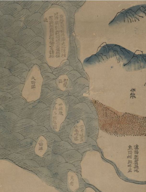
Figure 14: Detail from the far upper left hand corner of the 1811 Da Qing wannian yitong tianxia quantu (see Figures 2-4). Here, from top to bottom, we see several amorphous and somewhat ambiguously labeled land areas, all depicted as islands in the sea lying to the west of the strategic Central Asian region known as Yili (in modern-day Xinjiang): Holland, [the Land of] the Great Western Sea [probably Portugal], Spain, Arabia [lit., “The Homeland of Islam,” also identified with the name of an area in Central Asia known as Hami], the Small Western Sea, and Africa [lit. (the Land of the) “Black Ghosts”]. Source: The Library of Congress Map Room (online collection)
Yet at least a few indigenous mapmakers carried on the cartographic traditions established by the Jesuits—assisted now by the efforts of a new breed of Western missionaries, primarily Protestants. For instance, Li Mingche (1751-1832), a well-known Daoist priest and scientist with foreign contacts, included two relatively “modern” illustrations of the Eastern and Western hemispheres—complete with lines of latitude and longitude—in his Huantian tushuo (Illustrations of encompassing Heaven; 1819). Moreover, every late eighteenth and early nineteenth century example I have seen of the defensively oriented scrolls known generically as Haijiang yangjie xingshi quantu (Complete map of [China’s] coastal configurations) begins with a colorful and reasonably faithful line-drawn rendering of the eastern hemisphere based on Chen Lunjiong’s Haiguo wenjian lu—the same basic model that appears on Ma Junliang’s maps in the Tianxia quantu tradition and Cao Junyi’s Da Qing tongshu zhigong wanguo jingwei diqiu shi.
After China’s defeat at the hands of the British in the so-called Opium War of 1842, editions of the Haijiang yangjie xingshi quantu began to reflect a new awareness of the Western presence in treaty port areas—significantly, by means of textual remarks to the effect that “during the Daoguang period [1820-1850] Western countries [began to] trade at this place.” Such cartographic changes were part of a growing sense on the part of at least some Chinese scholar-officials that China had to acquire more up-to-date knowledge about the outside world in order to survive. The two most important books to provide this information, both based substantially on Western maps, were Wei Yuan’s Haiguo tuzhi (Illustrated gazetteer of the maritime countries; 1843), ably analyzed by Jane Kate Leonard (1984), and Xu Jiyu’s Yinghuan zhilüe (A short account of the maritime circuit; 1849), cogently discussed by Fred Drake (1975). What these two pioneering works had in common was a desire to, in Wei’s words, “describe the West as it appears to Westerners.”
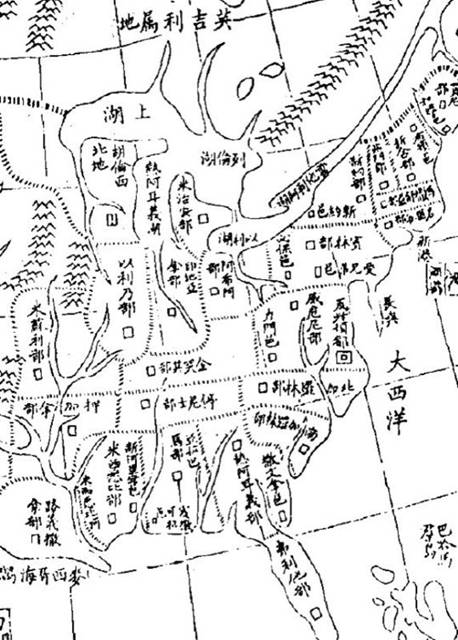
Figure 15: Eastern half of America from the Haiguo tuzhi (1875 edition)
From the 1860s to the early 1890s, as part of China’s Self-Strengthening Movement (1862-1895), study associations, books, and journals devoted to geographic and cartographic issues began to proliferate in China. Cartography became a recognized profession, and Chinese mapmakers increasingly produced maps of all kinds, including Western-influenced strategically oriented maps of potential trouble-spots. [Figures 15-17] Yet maps of the tianxia variety continued to circulate widely in Chinese society, not only as stand-alone items (sometimes displayed in multiple hanging scrolls) but also in almanacs and popular encyclopedias, and occasionally even as decorations on fans. Moreover, as late a 1881 a version of the explicitly strategic Qi sheng yan hai quan tu (Complete map of the seven coastal provinces) could still offer a map of the Eastern Hemisphere in which most of India and Southeast Asia remained totally unidentified. [Figure 18]
Then came the Sino-Japanese War of 1894-95, which sounded the death knell of traditional Chinese cartography. From this time onward, in elite journals and even popular publications, Chinese readers sought ever more accurate knowledge about other parts of the world, including once-despised Japan. The rise of Chinese nationalism—generated by China’s humiliating defeat at the hands of the so-called “dwarf-bandits” (wokou)—brought a heightened awareness of the wages of foreign imperialism. Chinese cartography, as with many other areas of Chinese life after 1895, became suffused with the spirit of patriotism and political action. One revealing illustration can be found in a map contained in a 1912 almanac (Zhonghua minguo yuannian lishu), issued in the name of the newly established Republic of China. Although not particularly sophisticated in terms of mathematical accuracy, the map is fascinating because its commentaries strikingly identify the various places “originally attached to our country” (yuan shu wo guo) but recently taken away by foreign imperialism. These places included the newly established (1885) province of Taiwan and the tributary states of Korea, the Ryukyu Islands and Vietnam. From this time onward, Chinese nationalism affected in fundamental ways the rendering of geographical space by cartographers in China.
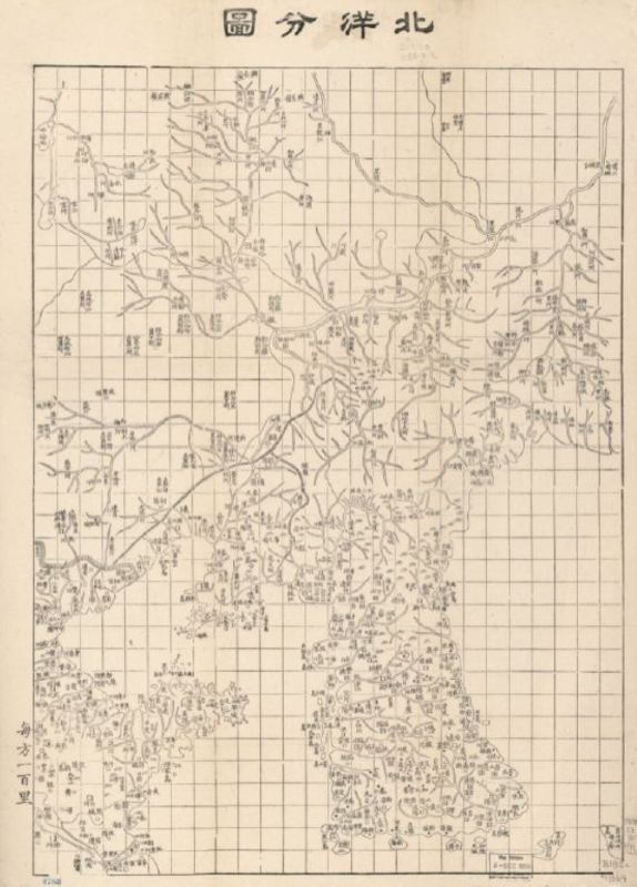
Figure 16: Beiyang fentu (Sectional map of the Northern Seas; 1864)—part of a comprehensive collection of strategically oriented maps produced by Chinese cartographers in 1864. Source: The Library of Congress Map Room (online collection)
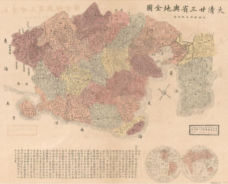
Figure 17: The Da Qing sanshi sheng yudi quanshu (Complete map of the twenty-three provinces of the Great Qing [dynasty]; 1885-1894). A particularly striking feature of this map—in addition to the two hemispheres drawn to scale on the bottom right—is the strategic emphasis on the trouble-spot of Korea, looming disproportionately large to the east of China Proper as an “appendix.” The Sino-Japanese War of 1894-95 began over competing claims of suzerainty over Korea. Source: The Library of Congress Map Room (online collection)
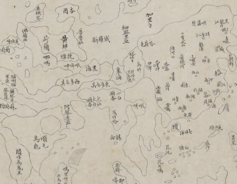
Figure 18: Detail from a map of the Eastern Hemisphere in the Qisheng yanhai quantu (Complete map of the seven coastal provinces; 1881). Note that in a map spanning from Korea to the Philippines in the east and Europe to Africa in the west, most of India and Southeast Asia remains completely unidentified. Source: The Library of Congress Map Room (online collection)
This material draws from, adapts and introduces “Mapping China’s World: Cultural Cartography in Late Imperial China,” chapter 2 of Richard J. Smith, Mapping China and Managing the World: Culture, Cartography and Cosmology in Late Imperial Times (Routledge, 2012)
Richard J. Smith is George and Nancy Rupp Professor of Humanities and Professor of History at Rice University, Houston, Texas. His book The I Ching: A Biography, was published by Princeton, 2012).
Recommended citation: Richard J. Smith, “Mapping China and the Question of a China-Centered Tributary System,” The Asia-Pacific Journal, Vol 11, Issue 3, January 28, 2012.
Bibliographical Note
In addition to the Asian-language sources cited in the book version of this chapter, see the excellent recent collection of Chinese maps edited by the Zhong hua yutu zhi bian zhi ji shu zi zhan shi xiang mu, titled Zhong hua yu tu zhi (An atlas of [ancient] Chinese maps) Beijing: Zhong guo di tu chu ban she, 2011. For a few additional English-language studies relevant to this chapter, consult Angela Schottenhammer and Roderich Ptak, The Perception of Maritime Space in Traditional Chinese Sources (Otto Harrassowitz Verlag, 2006); Wang Gungwu and Chin-Keong Ng, Maritime China in Transition: 1750-1850 (Otto Harrassowitz Verlag, 2004); Zhijun Ren, “Tributary System, Global Capitalism and the Meaning of Asia in Late Qing China” (MA thesis at the University of Ottawa, 2012), available here; Nianshen Song, “‘Tributary’ from a Multilaterial; and Multilayered Perspective,” Chinese Journal of International Politics, first published online (April 23, 2012) here, and Hsiao-ting Lin, “The Tributary System in China’s Historical Imagination: China and Hunza, cs. 1760-1960,” Journal of the Royal Asiatic Society of Great Britain and Ireland, 19.4 (October 2009): 489-507. For a useful analysis of the Wanguo laichao tu, see Jiang Peng, “Qianlong chao ‘Suizhao xingle tu,’ ‘Wanguo laichao tu’ yu shinei kongjian de guanxi ji qi yihan” (Interior space and the artistic motifs of “The myriad countries come to court” and “Having fun on New Year’s Day” in the Qianlong reign, along with their implications; Beijing Central Academy of Fine Art, MA thesis, 2010).
A wealth of online cartographic materials pertaining to the content of this chapter can be found at the magnificent Library of Congress Map Collection website. Most of the illustrations for this essay have been drawn from this source. Specific queries can be directed to their search engine, found here. To find a general item, enter, say, “China Maps” indicating a maximum of 400 bibliographic records for the category “Search All Map Collections.” This will yield 336 entries, including maps of all kinds—some large, some small; some produced by Chinese, Japanese or Korean mapmakers, some produced by Westerner cartographers; some modern, some ancient (the earliest are dated 1136); some rough, some strikingly beautiful in color and design. Some maps are mislabeled by the LOC, and so it takes a bit of trial and error to search for all the cartographic possibilities, but they are astonishing in their number and especially in their variety.
For a specific example of how one might look for maps, again focusing on China, go to “Search All Map Collections,” enter a term like “China Coast,” then “match any words” and keep the default at 100 bibliographic records.This will eventually yield “Eastern Hemisphere,” designated “Map 11 of 100.” You can then click on any of the several maps in the collection (all marked “880-01Hai jiang yang jie xing shi quan tu”), and go to the bottom of the page where it says “Download JPEG2000 image.” Click on this link. The download may take a minute or so, since it will be a rather large file, but then you’ll have a magnificent image on your desktop, which you can roam around in and magnify to a remarkable extent. From this action you can isolate and “grab” the specific image you want. It’s great deal of fun to poke around in this way, and I can guarantee that you will find some amazing material. Below, the titles of a few maps that I have downloaded recently, as a small indication of the possibilities for scholars of East Asia (these titles can all be entered directly into“Search All Map Collections,” sans the dates in brackets, which I have added):
Aihun, Luosha, Taiwan, Nei Menggu tu [1689-1722]
Bei yang fen tu [1864]
Chōsen hachidō no zu [1785]
Chungguk sipsamsong to [c 1800]
Da Qing fen sheng yu tu [1754-82]
Da Qing nian san sheng yu di quan tu [1885-1894]
Da Qing tong shu zhi gong wan guo jing wei di qiu shi [1794]
Da Qing wan nian yi tong di li quan tu [1814-16]
Da Qing wan nian yi tong tian xia quan tu [1811]
Da Qing yi tong yu di quan tu [1864]
Dian Yue Yuenan lian jie yu tu [1864]
Haedong chido [19th century]
Haejwa chondo [1822]
Hai jiang yang jie xing shi quan tu [1684-1787]
Hai jiang yang jie xing shi quan tu [1787-1820]
Hainan dao tu shuo [1820-1875]
Hamgyong-pukto chondo [19th century]
Hubei Anhui he tu [1864]
Hua yi tu [1136]
Huang chao yi tong yu di quan tu [1832]
Huang chao yi tong yu di quan tu [1842]
Huang chao zhi sheng yu di quan tu [1896]
Huang yu quan lan fen sheng tu [1693-1722]
Jiang hai quan tu [1800-1854]
Jing ban tian wen quan tu [c 1800]
Jing cheng ge guo zan fen jie zhi quan tu [1900]
Jing cheng quan tu [1870]
Kunyu wanguo quantu [1602]
Ming shi san ling tu [1875-1908]
Nan yang fen tu [1864]
Qi sheng yan hai quan tu [1881]
San cai yi guan tu [1722]
Sangoku tsūran yochi rotei zenzu [1785-1793]
Sankai yochi zenzu [1785]
Shan dong Zhi li Sheng jing hai jiang tu [c 1700]
Sheng jing yu di quan tu 1734
Wan li hai fang tu shuo [c. 1700]
Wan li hai fang tu shuo [1725]
Xia lan zhi zhang [c. 1647]
Xizang quan tu [1862]
Yihe yuan [post-1888]
Yojido [19th century]
Zhao tong Yun nan [1730-1820]