 |
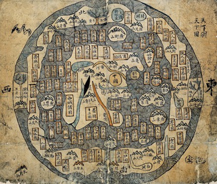
| “Cheonhado,” or imaginary map of the world. ( Seoul Museum of History) |
For many people, maps are simply a way of finding things, but the “Cartographic Achievement of Joseon” at the Seoul Museum of History shows how they were historically used to shape values and control information.
The exhibition, running until Feb. 28, features the changes in the production and use of maps in the Joseon period (1392-1910) and thereafter through more than 50 pieces donated by two scholars, Lee Chan and Hur Young-hwan.
From ruling to sharing
Maps in the early Joseon period rarely contained specific geographic information. Instead they had information needed for taxation ― the name of the village, population and possible tax-related information. Later they marked military barracks and other things, which were tagged as confidential.
“In the early Joseon era, only royalty and high-ranking officials were able to possess maps. Commoners were banned from even seeing them,” said Oh Ji-young, curator of the exhibition.
But after the Japanese invasion in 1592, widespread understanding of the importance of maps prompted those outside of royalty to acquire maps. People were allowed to carry maps that gave the distances between places, the estimated travel time and other information, which promoted the economy and trade.
From propaganda to science
In the early days, maps were used for propaganda by the royal Lee family, which struggled to gain legitimacy against the previous Goryeo Kingdom. The exact scaling and description of geography were ignored and the new capital Seoul’s feng shui was exaggerated to justify the move from Gaeseong. Some of the maps only marked the royal palace and the four divine mountains ― Bukaksan, Taraksan, Mokmyeoksan and Inwangsan ― to highlight the regime.
But as time passed, with the influence of the scientific cartography from China, which was influenced by European and Arabic ideas, maps started to be about geography.
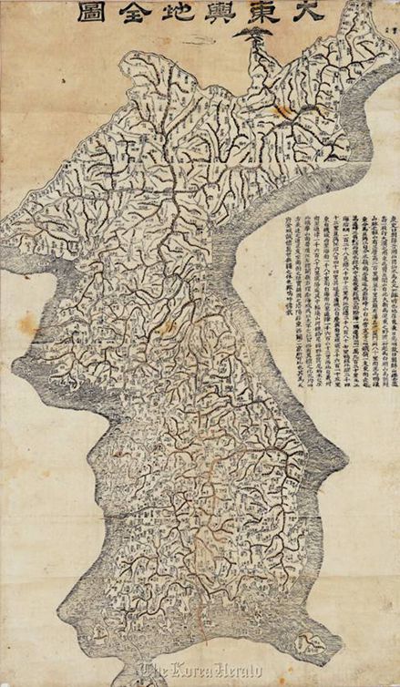 |
| “Daedongyeojido,” or detailed map of Korea. (Seoul Museum of History) |
“Daedongyeojido” (A Detailed Map of Korea) by Kim Jeong-ho in the mid-19th century is the summation of then-existing cartographic skills, including the scale. Grand illustrations of mountains were replaced with fine lines and major spots were marked with symbols for even the illiterate to find directions. He even mentioned the old castle or historic places that were destroyed, showing off his historical research.
During Japanese colonial rule (1910-1945), the Japanese government made precise maps about Joseon for taxation and exploitation. The road, traffic and transportation became more important than mountains and palaces while stream and sea measurements were more detailed than before.
The maps produced during this period also reflect the changing faces of the capital, which continued to expand. Yongsan, which was once a part of Gyeonggi Province, was annexed to Seoul when the Japanese military established barracks there, and since then has served as the military strategic point in the capital. After liberation in 1945, the Korean government, with the help of the U.S. Army and Dutch academics, managed to come up with more detailed maps using aerial photographs.
World according to maps
The people of Joseon often wondered about the world beyond the Korean peninsula. Due to the Confucianism and centuries-long Sinocentrism, China was often perceived larger than it is while other countries were often omitted.
“Cheonhado,” or imaginary map of the world, shows that people of Joseon pictured the world without actual information about the real world. Only four existing countries are mentioned ― China is puffed at the center of the map while Joseon, Japan and Yuku (Okinawa) are depicted as small islands. Other parts of the land are filled with imaginary names borrowed from Taoist books such as the countries of immortality, mountain gods and others.
The Honil Gangni Yeokdae Gukdo from the 15th century is the world’s oldest existing map that has all of Africa, Europe, Asia and Arabia together, reflecting the rather global perspective of the people.
“The map reflects the information Koreans possibly acquired from their friends in China and the Arabic world. The coloring of the waters in green proves that,” said Oh. “In this map, Korea is larger than China, which shows that Koreans were eager to show the Joseon Kingdom’s legitimacy and feel proud of it,” she added.
The exhibition is open from 9 a.m. to 8 p.m. on weekdays and 9 a.m. and 6 p.m. on weekends and public holidays. It is closed on Mondays.
By Bae Ji-sook (baejisook@heraldcorp.com)